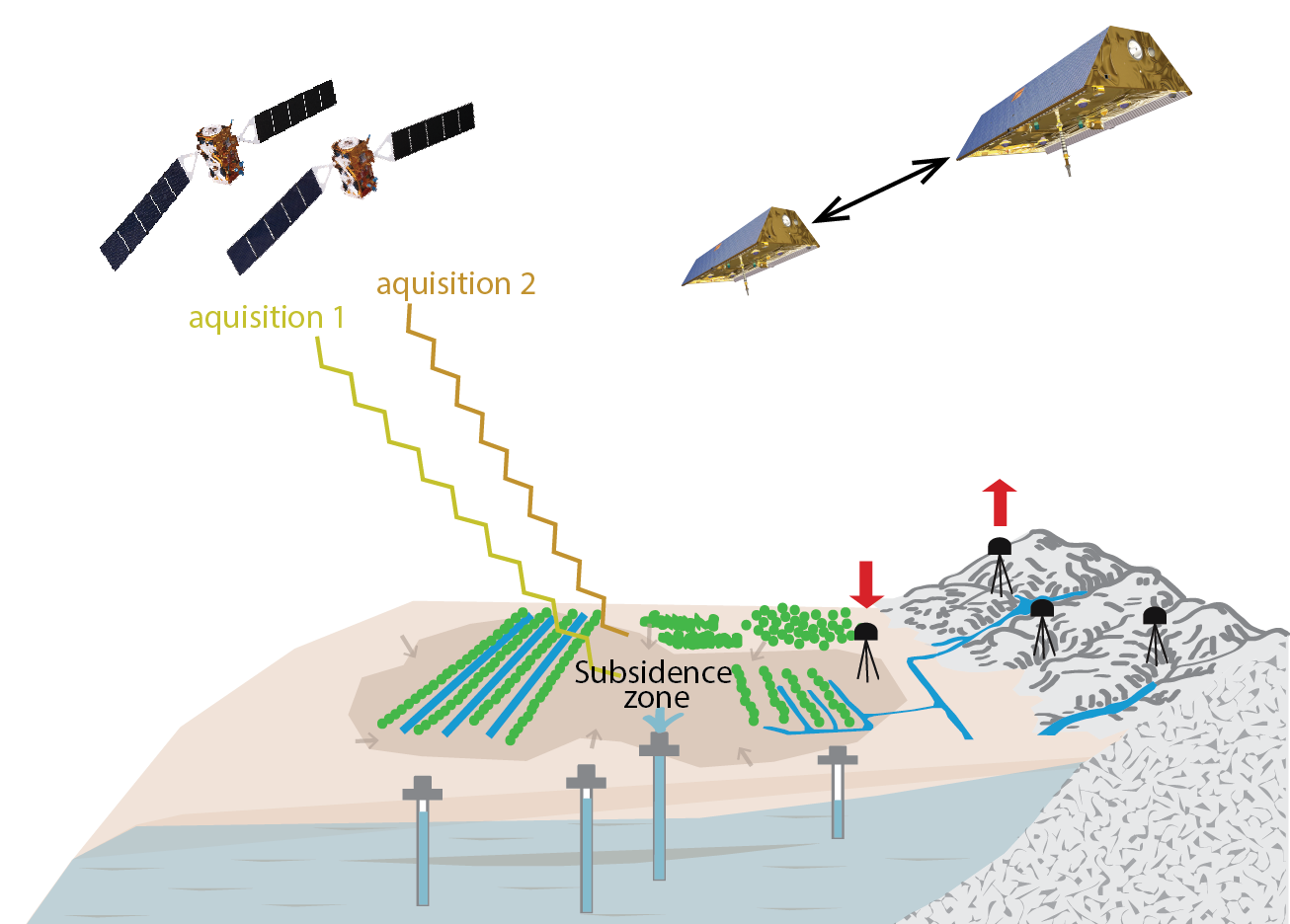
Terrestrial water storage changes (∆TWS) induce changes in Earth’s gravity field, measurable by the Gravity Recovery And Climate Experiment (GRACE) and its follow on mission (GRACE-FO). They cause elastic loading deformation of Earth’s surface, measurable by Global Navigation Satellite System (GNSS) displacements. In places with dense GNSS networks, it has been shown that GNSS station displacements can be used independently or in combination with GRACE/GRACE-FO to invert for water storage changes with a resolution ~3-5x higher than GRACE alone, depending on the station density. However, this technique often fails in places where other deformation processes are dominating the signal. This is the case above extensive confined aquifers undergoing fast poroelastic compaction due to groundwater pumping, causing an opposite response to that of elastic loading. Stations experiencing poroelastic deformation cannot be included in loading models, yielding a spatial observation gap above aquifers, where groundwater storage decline may contribute a significant proportion of ∆TWS. To fix this problem, the compacting aquifer deformation can be incorporated into the modeling framework. The advantage of such an approach is that it can provide an estimate not only of ∆TWS, but of groundwater storage change (∆GWS), too.
Grace Carlson, University of California, Berkeley, USA, und Susanna Werth, Virginia Tech, Blacksburg, USA
Resolving groundwater storage changes: Measuring two overlapping processes
Relied on by billions globally for drinking and crop irrigation, groundwater is our largest source of non-frozen freshwater. In California’s agricultural Central Valley, groundwater pumping helps sustain crop irrigation during extended periods of below normal precipitation, also known as drought. However, pumping has led to rapid groundwater level declines and land subsidence or sinking of the land surface. To quantify groundwater loss in the Central Valley during droughts, many researchers have turned to GRACE and GRACE-FO satellite data, which measures the cumulative change in water stored in snow and ice, rivers and lakes, in the soil, and under the ground. A good estimate of ∆GWS can be ascertained by removing remotely sensed or modeled storage components in other reservoirs from GRACE ∆TWS observations.

However, this approach can lead to large uncertainties due to the accumulation of error in all measured components and the low regional spatial resolution of GRACE observations. Therefore, it is advantageous to resolve ∆GWS by integrating other observations. Here, remotely sensed deformation signals are a great candidate, as they are directly attributable to water storage changes and aquifer dynamics.
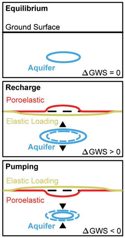
Removal of water mass causes a small, instantaneous, recoverable displacement of the Earth’s surface upward. Similarly, an addition of water mass will cause the surface of the Earth to sink. This effect is widely referred to as elastic loading. A second deformation process, poroelastic deformation, occurs above certain types of aquifer systems, where the removal of water causes an opposite deformational response, masking the elastic loading-induced deformation signals (Figure 1). Both deformation processes are present in signals observed at Global Navigation Satellite System (GNSS) stations, as well as via vertical land motion maps derived from interferometric synthetic aperture radar (InSAR). However, differentiating the overlapping poroelastic and elastic unloading processes in deformation datasets makes resolving water storage changes through inversion models challenging. But, by incorporating the physics of both poroelastic aquifer and elastic loading displacements into a modeling framework, along with GRACE, a more accurate, higher resolution, ∆GWS estimate may result.
A volume equivalent to more than 8,160,000 Olympic size swimming pools

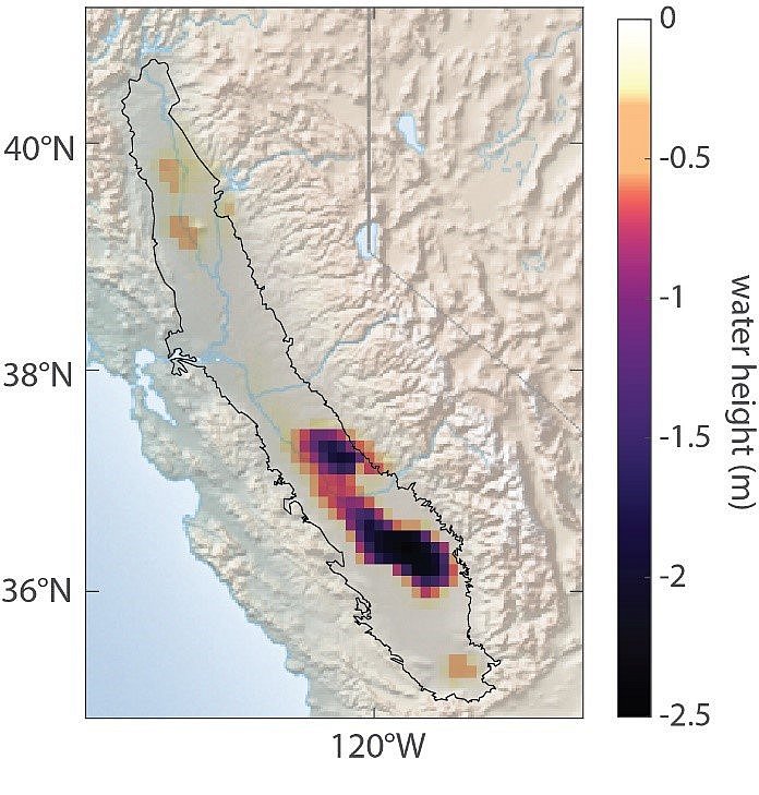
Using a novel combination framework integrating terrestrial water storage change from GRACE-FO and deformation from both elastic loading inside and outside of the Central Valley and poroelastic aquifer deformation over the Central Valley (from GNSS and InSAR), an estimate of the GWS lost in the Central Valley was determined. In total, deep aquifers in the Central Valley lost 20.4+/- 2.6 km3. This is equivalent to more than 8,160,000 Olympic-sized swimming pools! The applied novel method resulted in an unprecedented spatially detailed map of ∆GWS (Figure 2) only possible through the consistent integration of the three geodetic sensors GRACE-FO, GNSS, and InSAR, via complimentary geophysical models.
Further Reading
- G. Carlson, S. Werth, M. Shirzaei (2024): A novel hybrid GNSS, GRACE, and InSAR joint inversion approach to constrain water loss during a record-setting drought in California, Remote Sensing of Environment, Volume 311, 2024, 114303, ISSN 0034-4257, doi.org/10.1016/j.rse.2024.114303.
- Faunt, C. (2009): Groundwater availability of the Central Valley aquifer, California, Geological Survey Professional Paper
