Observing sea level changes with GRACE
The Earth's gravity field is caused by the distribution of masses within the Earth's interior and at the Earth's surface. Changes from one point in time to another can be caused by the spatial relocation of masses. Water currents in the world’s oceans are a prominent example of such mass transports, which can occur on very different time scales. The temporal changes of the sea level at Germany’s North Sea coast are characterized by the semidiurnal ebb and flow of the tides. Caused by super-positioned gravitational attraction forces of sun and moon, large-scale waves are excited in all major ocean regions. Tides vary in strength depending on the geometry of the ocean basins: While the North Sea experiences particularly strong water level changes due to incoming tidal waves from the Atlantic, tidal signals in the Baltic Sea are not discernible to the casual observer: here, flow obstacles in the area of the Danish islands and the Great Belt have a distinct dampening effect on tidal dynamics.
Gravity missions also record ocean tides
Sensor data from the GRACE and GRACE-FO satellite gravity missions contain certain aspects of ocean tides. However, these oceanic processes occur very quickly - the main lunar tide has a period of only 12 hours and 40 minutes - so that satellites cannot resolve the complete signal. Effects of ocean tides are therefore regularly subtracted during GRACE data processing by using external models. A global numerical model suitable for this purpose is also being developed at the GFZ (Sulzbach et al., 2021). In certain cases, however, it is possible to reveal deficits in such models with the help of GRACE data. This is especially the case in polar regions, where on the one hand a higher density of measurement data from gravity missions is available, and on the other hand the modelling of tidal dynamics is particularly complicated due to the presence of sea ice.
In addition to the tides, extreme water levels at Germany’s coastlines are generated in particular by onshore winds. If strong winds coincide with tidal peaks, storm surges lasting several hours pose particular dangers to coastal residents. These wind-driven oceanic effects are also registered by the gravity missions. Due to their short duration, these signals are also not directly measured in all cases, but routinely corrected via external models. For this purpose, the background model AOD1B has been processed at GFZ since 2002, and it is continuously distributed to all project partners in the USA and Germany. AOD1B is now available in version 07 (Shihora et al., 2023).
World map of sea level rise: Displayed is the trend of the mass component of sea level rise caused solely by water inflow into the oceans. At the equator (dark blue), a high rise is recorded, while in the North Atlantic near Greenland the sea level does not rise, but falls (red), even though a lot of additional meltwater is brought in there.

Karte: Eva Boergens, GFZ
Contributions to global sea level rise
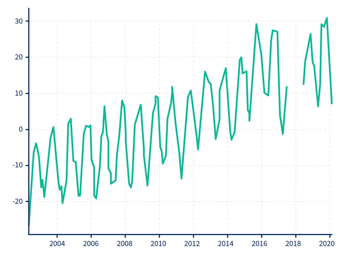
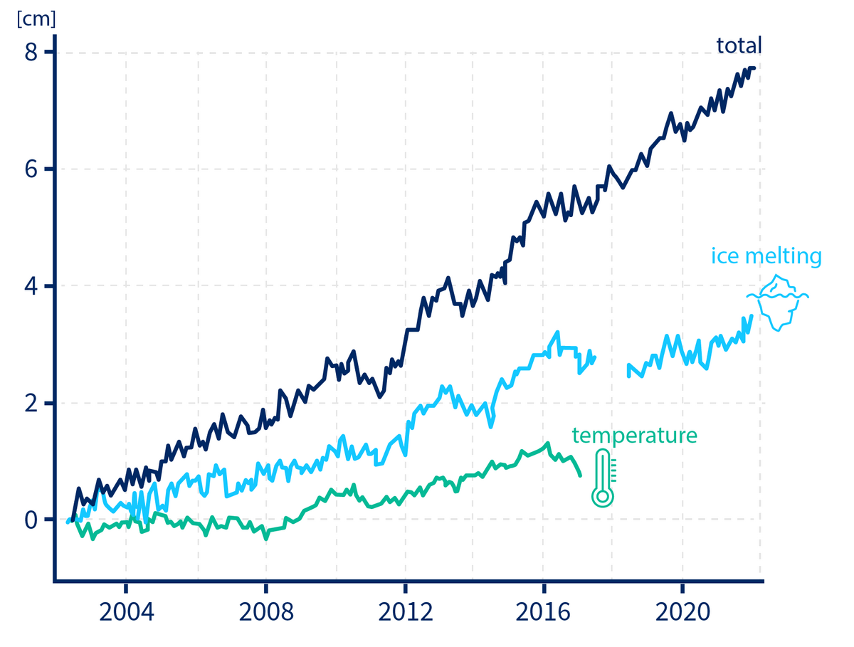
On long time scales, the change in the total mass of water contained in the oceanic basins is particularly visible in the GRACE and GRACE-FO data. About two millimetres of the annual rise in mean sea level is caused by an additional input of meltwater from ice sheets, ice caps and glaciers (Dobslaw et al., 2020). It is important to note that sea level rise is not the same everywhere in the world, but depends on the spatial distribution of mass anomalies across the continents, which cause a regionally variable gravitational attraction of oceanic water masses. For example, sea level around Greenland, with its strong continental ice mass losses, is rising less rapidly than in the central Pacific. This spatial variability of sea level rise is also referred to as the "fingerprint" of temporal changes in the large ice sheets covering Greenland and Antarctica.
Besides the input of additional meltwater, the thermal expansion of seawater due to global warming also contributes to sea level rise. This contribution cannot be sensed by gravity missions (since thermal expansion does not change the ocean bottom pressure), but it is instead recorded by radar satellites such as TOPEX/Poseidon or JASON. By combining gravimetric and altimetric measurements, it is thus possible to quantify temporal changes in the total amount of heat stored in the oceans. The resulting global energy imbalance is currently around 0.74 watts per square metre of the Earth's surface (Marti et al., 2022). This implies that, on average, 0.2% more energy from solar radiation is absorbed than it is released back into space.
Due to various feedback mechanisms in the Earth system, however, there are long-term limits to the thermal expansion of seawater. The large ice sheets in Greenland and Antarctica, on the other hand, have the potential to cause a total sea level rise of up to 7 and 58 metres respectively. Numerical models predict slowly increasing ice mass loss particularly in West Antarctica and Greenland (Payne et al., 2021). There is already evidence of ongoing changes in the polar regions in the data from a wide range of satellites, so that a continued rise in sea level is foreseeable, and the contribution of additional meltwater will become more important relative to thermal expansion. For the precise documentation of these two very different contributions to sea level rise, the simultaneous operation of both altimetry missions (after JASON-3) and gravity satellites (in succession to GRACE-FO) is also urgently required in the future.
Signatures of the Meridional Overturning Circulation
In addition to the large-scale signals of mass-induced sea level rise, there are also spatially confined variations in oceanic bottom pressure along the shelf slope off the American east coast, which are causally related to variations in the transport of North Atlantic Deep Water, and thus the meridional overturning circulation. The near-surface part of this overturning circulation, the Gulf Stream, is largely responsible for the relatively mild climate in north-western Europe (Bingham and Hughes, 2008). These signals have not yet been reliably detected in the GRACE and GRACE-FO data, making their detection an important goal for future improved gravity field missions.
Text: Dr. Henryk Dobslaw, GFZ
Advantages of the GRACE concept to measure sea level changes
The GRACE satellite missions represent the only currently known remote sensing concept that provides quantitative information on mass redistributions between continents and oceans. This means that, for the first time, the amount of meltwater contributing to sea level rise can be precisely quantified and visualised as a separate component over time. Meltwater accounts for roughly 50 % of the current total increase (see figure). The separation of the various contributions to sea level rise is important for the validation of numerical models, which are employed to forecast future sea level changes.
Further reading
- Article in the GFZ Journal System Earth (2/2017): Oceanographic applications of the GRACE mission, PDF
- Scientific article on the determination of sea level rise from GRACE observations: Dobslaw et al. (2020)
- Scientific article on global energy imbalance from satellite measurements: Marti et al. (2022)
- Scientific article on long-term sea level rise due to Antarctic and Greenland ice mass loss: Payne et al. (2021)
- Scientific article on ocean bottom pressure signals from the Atlantic meridional overturning circulation: Bingham and Hughes (2008)
- Scientific article on the atmospheric-ocean background model AOD1B: Shihora et al. (2023)
- Scientific article on numerical tidal modelling at the GFZ: Sulzbach et al. (2021)


