
Water reservoirs are an essential part of the global water cycle. Independent of their water residence time, they are highly beneficial in different ways to both nature and humans. At a site in Northern-Germany, within the TERENO-North East Observatory, ongoing research looks at the combination of satellite-based measurements of water storage changes and terrestrial gravity surveys within a dedicated gravimeter network. This combination would enable those investigations requiring higher temporal and/or spatial resolutions of water storage changes, which GRACE/GRACE-FO still cannot provide up to now.
Dr. Marvin Reich, GFZ
Terrestrial gravimetry in North-Eastern Germany
The TERENO-North East Observatory was established in 2011 as a focus area for investigations and research on processes of global change interacting with natural environments. Within this long-term project, section 4.4 Hydrology of GFZ maintains numerous measurement sites for continuous monitoring of precipitation, soil moisture, groundwater, lake levels, sapflow in trees and other relevant hydro-meteorological parameters. In addition to traditional hydrological methods, terrestrial gravimetry was included as an additional applied field method.
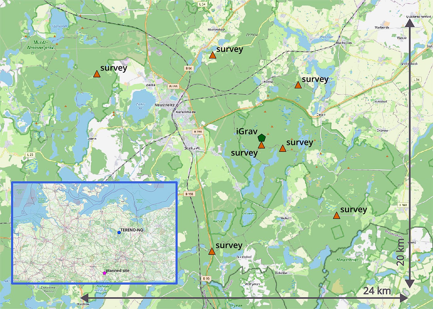
Since 2017, a superconducting gravimeter (iGrav, company GWR) is continuously measuring the changes of local gravity and consequentially mass variations on top and below the Earth’s surface. Measurements are processed with a focus on regional water budgets. This implies the removal of all non-hydrological information from the obtained gravity observations. In combination with the independent measurements of soil moisture and groundwater tables, individual storage compartments can be analyzed. The footprint of the gravimeter at this site extents over a radius of approximately 2 km around the device. This spatial extent for analyzing gravity changes was enlarged within the scope of the Collaborative Research Centre “TerraQ” (German Research Foundation, coordinated by University of Hannover): since 2022 frequent, regional gravity surveys around the iGrav are conducted (see figure 1).

During these seasonal surveys, spatially distributed representative points are repeatedly visited with spring gravimeters (CG-6, company Scintrex). Data analysis is conducted jointly with the continuous time series of the iGrav.
Changes of the long-term device-specific behavior (drift) of the iGrav are additionally monitored (and adjusted), using the new absolute quantumgravimeter (AQG, company Exail). In total 3 different gravimeter types with individual and device-specific spatio-temporal resolutions are contributing in this focus area (see figure 2).
From local to regional large-scale statements on changes of water storage
The above described measurement program is ongoing. We are investigating how much the data of a single superconducting gravimeter is representative for a larger region. The long-term aim of this analysis is to combine terrestrial and satellite-based gravimetry. To this end, the "TerraQ" project will use the example of the TERENO-North East site to investigate how such terrestrial measurements (including GNSS surface load effects) can contribute to an improved spatio-temporal resolution of GRACE/GRACE-FO. With monthly data in an area of approx. 300 x 300 km, both the temporal and spatial resolution of satellite-based terrestrial water storage changes (TWA) is still quite coarse and insufficient for some application-oriented and socially relevant questions. Examples of this are statements about the availability of local groundwater resources, their targeted extraction for drinking water and agriculture, or the development of the soil water balance of trees and plants in dry summer periods. Linking the aforementioned observation methods is therefore very promising in order to be able to quantify water storage changes for research questions with different spatio-temporal references more precisely in the future using high-resolution, combined data products.
Further information
- Hydrological research within TERENO Nordost at GFZ (https://www.gfz-potsdam.de/en/section/hydrology/projects/tereno-terrestrial-environmental-observatories)
- Hydrograviemtry at GFZ (https://www.gfz-potsdam.de/en/section/hydrology/projects/hygra-terrestrial-gravimetry-for-hydrological-applications)
- Collaborative Research Centre TerraQ, subproject C05 (https://www.terraq.uni-hannover.de/en/research/projects/research-area-c-gravity-modelling-and-applications/project-c05)