
Satellite gravimetry has great potential for improving numerical Earth system models that simulate Earth system processes and the interactions between its components, e.g. between the atmosphere and the land surface. Observations from the GRACE and GRACE-FO satellite missions provide a 20-year time series of changes in terrestrial water storage, which can be used to improve the representation of the water cycle in these models. In the Collaborative Research Centre DETECT, researchers are working on integrating the GRACE/-FO data into a high-resolution, fully coupled Earth system model over Europe. This optimized Earth system model makes it possible to study the impact of human activities on the European climate, such as changes in land use or irrigation practices.
Anne Springer, University of Bonn
How can numerical models help us to better understand our Earth system?
In a small community garden on the Meßdorfer Feld in Bonn, several dozen gardeners eagerly await spring every year. They ask themselves questions such as: Is the soil dry or wet? How much water do we need? How long does the soil retain moisture in the root zone? And is it wise to plant snake cucumbers?
In science, such questions are translated into mathematical equations within land surface models. These models simulate water and energy fluxes as well as biogeochemical processes at the Earth's surface and in the soil. They rely on atmospheric forcing data and information about surface properties such as topography, land cover, and land use. For this purpose, the land surface is divided into grid cells and, in the vertical dimension, into several depth layers. At each time step, the model calculates key state variables—such as temperature and water content in each soil layer, evaporation, transpiration, and reflected radiation—for every grid cell. The goal of land surface modeling is to understand the complex interactions between soil, water, vegetation, and atmosphere, while also considering human influences on the natural system.
How can satellite observations improve Earth system models?
However, models are naturally subject to errors caused by incorrect process representations or uncertainties in the input data. For example, trends in water storage are often poorly captured. By assimilating GRACE/-FO-derived changes in terrestrial water storage, model variables contributing to water storage - such as soil moisture, ice in different soil layers, snow, water in vegetation, and groundwater - are updated. Data assimilation relies on algorithms like the Ensemble Kalman Filter, which adjusts model variables by calculating increments based on observational and model uncertainties. This process can also be interpreted as a form of spatial and temporal downscaling, meaning the refinement of the originally coarse-resolution GRACE/-FO data to achieve a higher level of spatial and temporal detail.
How do GRACE/-FO observations contribute to a high-resolution land surface reanalysis over Europe?
In the Collaborative Research Centre DETECT, GRACE/-FO data are assimilated into the high-resolution Community Land Model Version 5 (CLM5) at the University of Bonn in cooperation with the Jülich Research Centre. The result is a so-called land surface reanalysis.
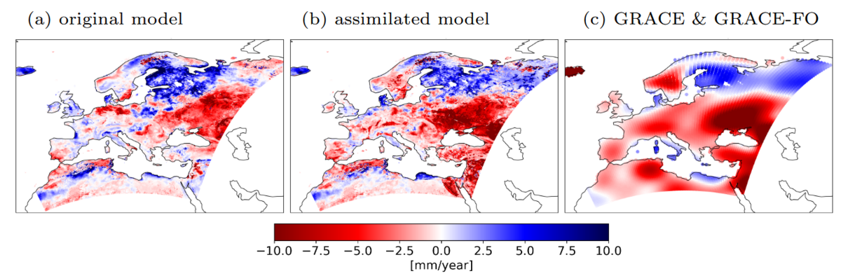
Figure 1 illustrates spatial trends in terrestrial water storage over nearly 20 years, comparing results with and without the assimilation of gravity field data. For context, trends from satellite data—which obviously have a coarser resolution than the model—are also shown. It can be observed that the GRACE/-FO satellites indicate a stronger negative trend (water loss) across much of Europe compared to the original model. Data assimilation drives the model towards the GRACE data, leading to more pronounced negative trends in terrestrial water storage, either newly emerging or being strengthened, particularly in the Balkans, Scandinavia, the Iberian Peninsula and Central Europe.
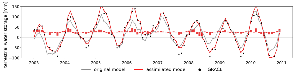
Focusing on a specific river basin, such as that of the Dnipro River, which flows through Ukraine to the Black Sea, it can be observed that both the trends and the extremes in the time series are better captured in the case of GRACE/-FO assimilation (Figure 2).
The adjustment of the modeled terrestrial water storage includes updates to the soil moisture in the different soil layers and the thickness of the snow cover, but indirectly adjusts many other model variables such as soil temperature, evapotranspiration, surface runoff, etc. Whether these variables are actually closer to reality is validated with external observational data. Overall, the reanalysis helps us to get a more accurate picture of reality and to identify model deficiencies.
How are humans changing the regional climate?
Within DETECT, the improved land surface model will be coupled with an atmospheric model to analyze the interactions between the land surface and the atmosphere in greater detail. This coupled assimilation system will also allow for the analysis of how land use changes—such as replacing forests with arable land or intensifying irrigation—impact the regional water and energy cycle. Ultimately, the enhanced model aims to improve our understanding of the role humans play in regional climate processes. Meanwhile, the gardeners at Meßdorfer Feld have just received the results of a soil analysis and will be sowing broad beans in the coming days.