The combination of GRACE and CryoSat-2 improves determination of mass changes in Antarctica
One of the consequences of climate change is the retreat of the Antarctic ice sheet, which is driving sea level rise. GRACE and GRACE-FO (hereafter simply referred to as GRACE) can measure the mass changes of the Antarctic ice sheet and help us to better understand how these processes take place. By calculating the mass changes not only from the GRACE data, but also using satellite altimetry observations from the CryoSat-2 mission, it is possible to obtain a much higher spatial resolution of the mass changes. Moreover, it is possible to calculate the effects of glacial isostatic adjustment (GIA) directly without using a computer model (post on GIA) in Antarctica. The results then agree even better with independent data.
Dr.-Ing. Matthias Willen, Technische Universität Dresden
GIA and spatial resolution are challenges for calculating accurate ice mass changes in Antarctica der Antarktis
The post on GIA explains why it is so important to know the processes in the Earth's interior. In fact, GRACE can only measure the sum of e.g. ice mass changes and changes in the Earth's interior. In Antarctica, the ice mass changes and the effects due to GIA are of a similar order of magnitude. However, GIA in Antarctica is only imprecisely known and these uncertainties affect the calculated ice mass changes. In addition, the spatial resolution of the GRACE data of a few hundred kilometers is often too coarse to study glaciological processes in detail, as e.g. a changing flow behavior of glaciers.
High spatial resolution of ice mass changes and GIA in a single step
Satellite altimetry, e.g. CryoSat-2, does not measure mass changes, but volume changes. In order to combine these with GRACE, the volume changes must be converted into mass changes. This is a particular challenge in the firn layer of the ice sheet. Firn is the material in the transition from snow to glacier ice and is basically a mixture of ice and air. The density of this layer varies a lot. However, the conversion into mass changes is possible by subtracting the changes in the air content in the snow and firn layer, so that only the changes of the ice content remain. Results from regional climate modeling and firn modeling can be used to determine the changes of this air content. In addition, the observations, i.e. GRACE and CryoSat-2, must be linked to the signals of the mass and volume changes, i.e. ice, GIA and firn air content. This link is the so-called parametrization and describes the physical relationship between measurement and signal. This parametrization is chosen in such a way that the ice mass changes can be highly resolved and the calculation of GIA is possible on the basis of physical relationships. In addition, the parametrization is chosen in a way that is consistent with other mass changes in the Earth system. Finally, a large system of equations is obtained, which has to be solved. The solution is a set of numerical values for e.g. ice mass changes and GIA. The uncertainties of the observations and their correlations are taken into account as comprehensively as possible in the calculation.
Almost 1500 Gigatons of ice mass loss in 10 years
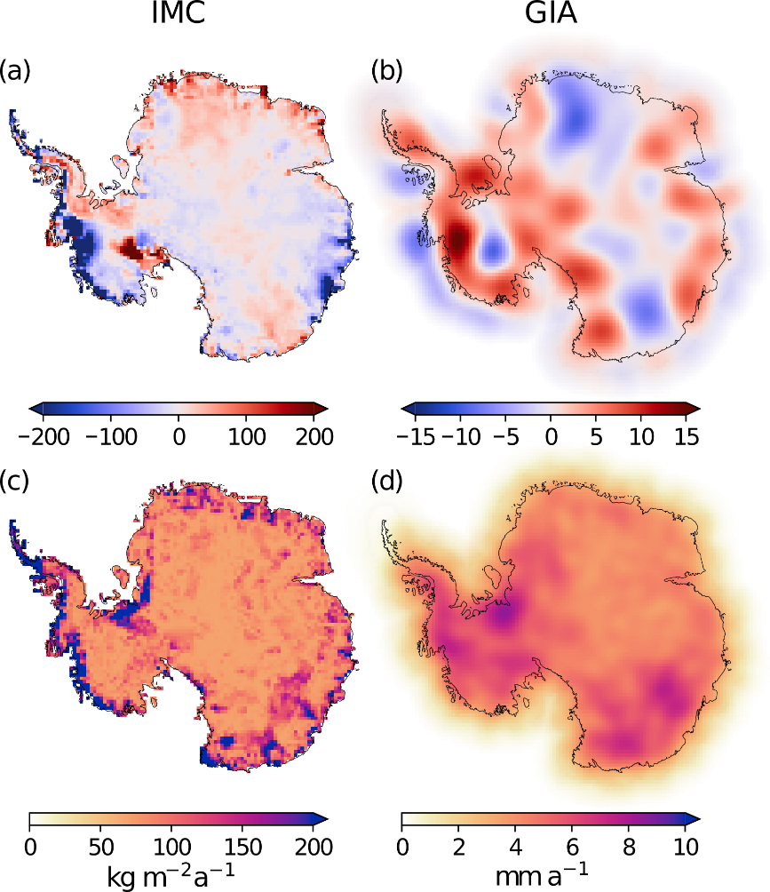
The calculation shows that the Antarctic ice sheet lost an average of -144 ± 27 gigatons of ice mass per year from January 2011 to December 2020, i.e. over 10 years. In 10 years, this corresponds to a huge ice cube almost 12 kilometres wide, 12 kilometres long and 12 kilometres high.. However, where these mass changes occur varies strongly (Fig. 1a). The greatest mass loss is taking place in West Antarctica. However, there are also areas where mass has been gained. Overall, the Antarctic ice sheet has lost mass and computer simulations show that this loss of ice mass will accelerate in future. However, the results of the simulations are still very different. In order to find out how large the ice mass loss will actually be in the future, the results from the combination of GRACE and CryoSat-2 can help to improve the models for such projections.

© Matthias Willen
The in-parallel calculated effects of GIA (Fig. 1b) agree even better with independent GNSS measurements (e.g. GPS) than other calculations. But they still contain errors that will be corrected in the future. In contrast to computer models, these calculated GIA effects from satellite observations cannot simulate the processes in the Earth's interior. However, they may contribute to making computer models for simulating GIA more realistic in the future.
Reading tip
- Focus page: Mass balance of continental ice sheets
Further reading
- Willen, M. O., Horwath, M., Buchta, E., Scheinert, M., Helm, V., Uebbing, B., and Kusche, J.: Globally consistent estimates of high-resolution Antarctic ice mass balance and spatially resolved glacial isostatic adjustment, The CryosphereThe cryosphere is all parts of a climate system that are covered with ice. The Earth's cryosphere includes glaciers, polar ice, ice sheets, sea ice and snow. The cryosphere is an important indicator of climate change and contributes significantly to ..., 18, 775–790, doi.org/10.5194/tc-18-775-2024, 2024.
- Willen, M.O., Horwath, M., Groh, A., Helm, V., Uebbing, B., and Kusche, J.: Feasibility of a global inversion for spatially resolved glacial isostatic adjustment and ice sheet mass changes proven in simulation experiments. J Geod 96, 75 (2022). doi.org/10.1007/s00190-022-01651-8
