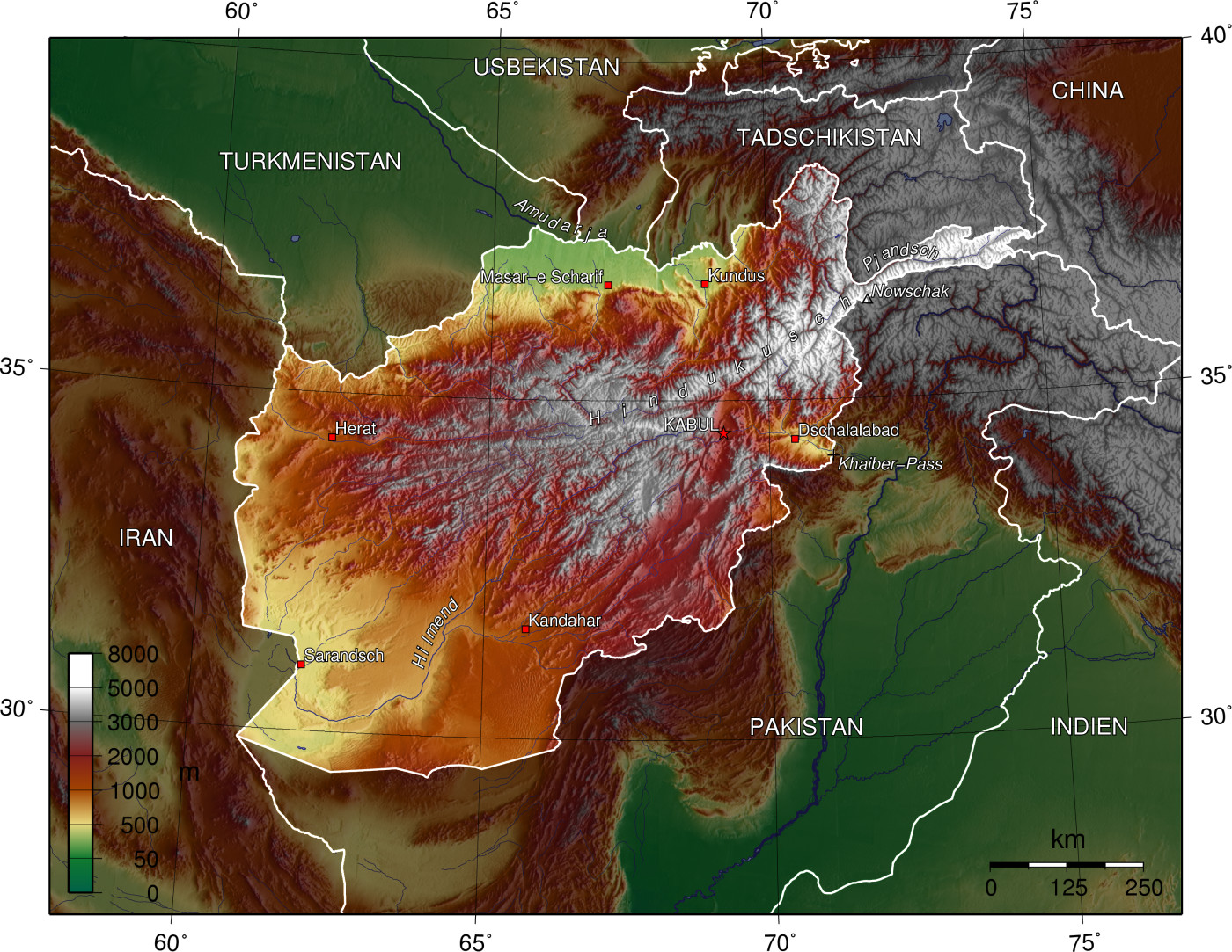
Water is a vital resource for livelihood and development, yet its availability is increasingly at risk due to climate change and anthropogenic activities. More than 80% of Afghanistan’s water comes from the snowmelt, however a declining trend in snow cover is posing a major threat to the country’s water resources. Therefore, understanding long-term water storage trends is crucial for sustainable management, and satellite gravimetry is an important information source to improve process knowledge.
Abdul Haseeb Azizia, Fazlullah Akhtara, Bernhard Tischbeina, Christian Borgemeistera, Qiuyu Wangb
a University of Bonn, Germany
b Chinese Academy of Sciences, Beijing, China
Quantifying Changes in Afghanistan’s Water Storages
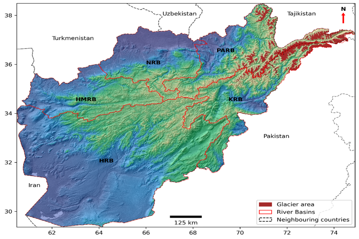
A new study employs cutting-edge tools, including remote sensing from GRACE/-FO and other satellites, machine learning, reanalysis data and hydrological models’ data, to assess Afghanistan's terrestrial water storage (TWS) dynamics over two decades (2003–2022). The five major river basins of Afghanistan (i.e., Harrirud-Murghab, Helmand, Kabul, Northern, and Panj-Amu) play a crucial role in managing the country's surface and groundwater resources (Figure 1). These basins are characterized by significant variability in terms of ecological conditions, snow cover, and groundwater depletion. The results of this research underscore the significance of integrating diverse datasets and advanced analytical tools to address global challenges to groundwater storage in Afghanistan. Our work illustrates the complex interplay of climate, hydrology, and anthropogenic activities, underscoring the necessity for regional and international collaboration in the management of water resources.
Research Methodology
The methodology integrates satellite observations (e.g., GRACE and the Ice, Cloud, and Land Elevation Satellite (ICESat)). It also incorporates hydrological models (e.g., WaterGAP and Global Land Data Assimilation System (GLDAS); Catchment Land Surface Model (CLSM)) and reanalysis datasets (Global Land Water Storage (GLWS) and ERA5-Land). Furthermore, climate variables (precipitation, temperature, and potential evapotranspiration) are included to enhance the analysis. Machine learning techniques, including Artificial Neural Networks (ANN) and Random Forests (RF), are employed to reconstruct Terrestrial Water Storage Anomalies (TWSA), fill data gaps, and extend the temporal coverage of GRACE observations. Seasonal Trend Decomposition using Loess is applied to assess trends and seasonal variations in TWSA. Glacier thickness and mass changes are estimated using ICESat and ICESat-2 data, while the predictive accuracy is validated using multiple performance metrics, including Pearson's correlation coefficient and Nash–Sutcliffe efficiency. The methodology also includes deriving spatial trends in TWSA and water storage components using linear least squares, with significance tested via Student's t-distribution at the 95% confidence level.
Key Insights of the Study: Afghanistan Water Storage is Declining
The study results indicate a strong correlation (R = 0.90–0.97) between the reconstructed and observed Terrestrial Water Storage (TWS) anomalies across the major basins of Afghanistan. From those results, we infer that
Afghanistan experienced a net loss of approximately 2.46 Gt/year in TWS from 2003 to 2022. Groundwater depletion was responsible for 36.7% of this decline, while glacier mass retreat contributed 49.1%.
The major loss in TWS was driven by the glacier retreat (i.e. -1.21 Gt/year) followed by groundwater depletion of about -0.90 Gt/year.
The largest TWS loss was experienced in the Helmand River Basin caused by groundwater depletion at a rate of 1.18 Gt/year which accounts for 80.1% of the total TWS signal.
From all catchments in Afghanistan, the Helmand River Basin experienced the most significant reduction in TWS at a rate of approximately 1.47 Gt/year. This decline is largely attributed to unsustainable groundwater extraction practices. In contrast, the Panj-Amu and Kabul River Basins showed considerable glacier mass loss, which highlights the region's vulnerability to climate-driven changes.
Seasonal fluctuations in precipitation and snowmelt have a significant impact on TWS variability. However, long-term declines highlight the urgent need for effective and sustainable water management strategies. Positive anomalies were observed in TWS from March to May, mainly because of the snowmelt and contribution to the groundwater recharge. In contrast, negative anomalies were observed from September to November due to the dry weather conditions.
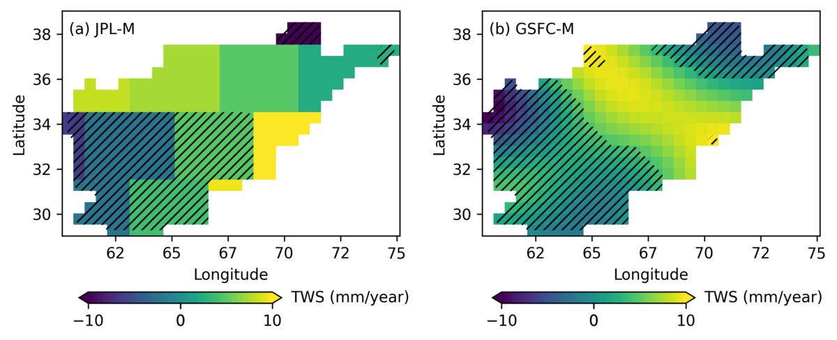
Figure 2 provides the spatial distribution of TWS trends in Afghanistan from 2003 to 2022. Data from both JPL-M and GSFC-M indicate a significant decline in TWS across the northern, northeastern, southern, southwestern, and western regions of the country.
This study provides new insights into the hydrological changes occurring in Afghanistan and its major river basins, while also supports to establish model-based approaches for the analysis of water storage in other data-scarce regions. These insights can help the international investment agencies including the Ministry of Agriculture, Irrigation and Livestock, Ministry of Energy and Water, Ministry of Rural Rehabilitation and Development, Ministry of Urban Development & Land, and National Environmental Protection Agency develop evidence-based strategies to address water scarcity and climate change adaptation.
The study on Afghanistan’s water storage dynamics aligns with ZEF’s mission to contribute to sustainable development and foster solutions for resource management in regions facing complex challenges due to climate change and anthropogenic pressures. Furthermore, the achieved findings can considerably foster international cooperation and thereby lower conflict potential as the major basins in Afghanistan are part of transboundary basins.
Further Reading
Azizi, A.H., Akhtar, F., Tischbein, B., Borgemeister, C., and Wang, Q. (2024) Assessing long-term water storage dynamics in Afghanistan: An integrated approach using machine learning, hydrological models, and remote sensing, Journal of Environmental Management, 370, 122901. https://doi.org/10.1016/j.jenvman.2024.122901.