The spatial resolution of the GRACE missions is limited, partly by the amount of sensor data required to process a global gravity field. Data over a period of 30 days is typically used to determine a single monthly field. In a separate step, linear trends of terrestrial water storage can then be estimated from more than 200 individual monthly fields that have been recorded with GRACE and GRACE-FO since 2002. However, a recently published article (Kvas et al., 2024) describes a mathematical method that can be used to determine long-term trends in a single joint inversion. This allows the spatial resolution to be significantly increased beyond the level known from monthly solutions.
Dr. Andreas Kvas, Felix Öhlinger und Prof. Dr.-Ing. Torsten Mayer-Gürr, Graz University of Technology
The satellite as a sensor in the Earth's gravity field
Unlike many other remote sensing methods, the spatial resolution of satellite gravimetry is not determined by the optical parameters of a camera or the carrier frequency of a radar system. Instead, the spacecrafts of each of the satellite missions GRACE and GRACE-FO act as sensors, moving without propulsion in the Earth's time variable gravitational field. The exact position and velocity, as well as the non-gravitational forces acting on the satellite, are measured by a series of very precise instruments. These include in particular (1) the continuous ranging measurement between the two twin satellites; (2) the positioning relative to the higher-flying GPS satellites; (3) the measurement of all non-gravitational forces using a three-dimensional accelerometer in the centre of mass of the respective satellite and (4) the orientation of the satellites in space using star cameras. A spatially varying Earth gravity field can only be determined from the combination of all this information. The differences between gravity field estimates at different points in time then provide information about temporal changes from which conclusions about the increase or decrease in terrestrial water storage can be drawn.
Temporal versus spatial resolution
The spatial resolution of conventional GRACE/GRACE-FO gravity field products is limited to a few hundred kilometres. This limitation is due to the period of the collected sensor data (usually one month), the altitude of the satellites, and the measurement noise of the instruments. The gravitational forces acting on the GRACE/GRACE-FO satellites at an altitude of around 500 km are significantly weaker compared to the Earth's surface. However, the received signal must be propagated to the Earth's surface when determining the gravitational field and subsequently the change in mass. During this process, the high-frequency measurement noise is particularly amplified. To counteract this, low-pass filters are traditionally used, which smooth the solution spatially and thus further limit the resolution. However, if all the measurement data of the time series are considered simultaneously and evaluated to determine the trend, rather than the respective monthly solutions, the spatial resolution can be significantly increased, as certain parts of the measurement noise average out.
Higher resolution for regional hydrological studies

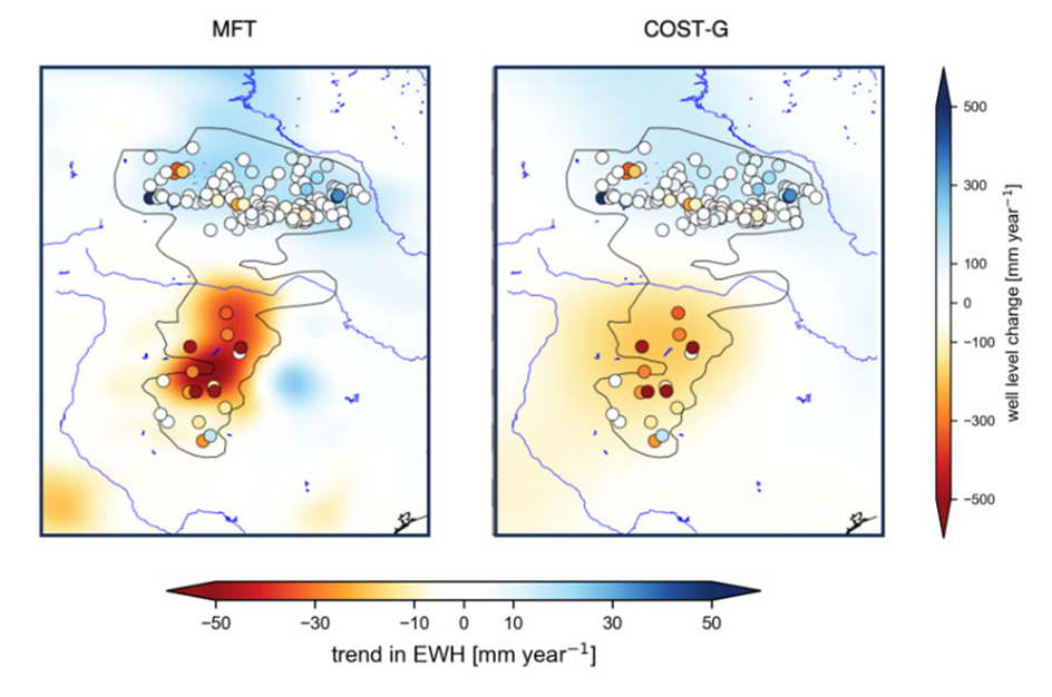
An example is shown for the Ogallala aquifer region in the southwest of the USA (Figure 1). The opposing trends of terrestrial water storage north and south of the Arkansas River are also well resolved by the monthly solutions (shown here is the combined solution of the COST-G Service of the International Association for Geodesy). However, particularly pronounced regional groundwater depletion in northern Texas or the slight increase in water levels west of the Missouri River can only be detected by the newly developed joint adjustment (denoted here as mean field trend estimate (MFT)). The new method thus provides an unprecedented spatial resolution, which can subsequently be used for further hydrological and hydrometeorological studies in other regions of the world.
Further Reading
Andreas Kvas, Eva Boergens, Henryk Dobslaw, Annette Eicker, Torsten Mayer-Guerr, Andreas Güntner: Evaluating long-term water storage trends in small catchments and aquifers from a joint inversion of 20 years of GRACE/GRACE-FO mission data, Geophysical Journal International, Volume 236, Issue 2, February 2024, Pages 1002–1012, https://doi.org/10.1093/gji/ggad468
