In a recently published study, researchers from the Leibniz University Hannover introduce an innovative approach to reveal ocean tide model errors and unmodeled ocean tide components in GRACE and GRACE Follow-On distance measurements. This approach opens up the possibility of using the inter-satellite distance measurements for the development of next-generation ocean tide models.
Igor Koch, Leibniz Universität Hannover
Temporal variations of the gravity field of the Earth, for example, caused by seasonal groundwater level fluctuations, climate-induced ice mass loss or major earthquakes, are nowadays monitored using satellites. The underlying idea is simple: since the movement of satellites is influenced by the mass distribution on Earth, precise satellite position data can be used to derive information about the underlying masses. A refined modification of this principle is employed by the GRACE (2002-2017) and GRACE Follow-On (since 2018) satellite gravimetry missions. Not only are the satellite positions known extremely accurately (thanks to GPS technology with a centimeter level accuracy), but also the distance between the satellites. The distance can even be measured with a micrometer level precision, which makes it possible to observe the state of the Earth's gravity field with a spatial resolution of a few hundred kilometers and a temporal resolution of about one month.
However, the movement of the satellites is not only affected by the masses on Earth that we are interested in, but also by a number of perturbing effects. To eliminate these, they have to be removed from the measured distance data using models. These effects include, for example, the attraction of the satellites by other celestial bodies, atmospheric drag, as well as tidal effects caused by the Moon and Sun. In particular, mass redistributions with a shorter period than the monthly resolution of the Earth's gravity field products must be modeled precisely. Model errors not only degrade the general quality of the gravity field products, but can also lead to high-frequency perturbation effects being incorrectly interpreted as slow mass changes. Ocean tides represent such a challenging effect. In order to obtain an accurate ocean tide model, numerical models are combined with data from altimetry satellites that measure the sea level relative to the satellite orbit. However, these satellites do not cover polar and subpolar areas of the Earth, which leads to model inaccuracies in these regions. In addition, ocean tide models exhibit shortcomings in coastal regions, where the interactions of tidal waves with coastlines are quite complex and the sea level sampling by the altimetry satellites too coarse.
Through an alternative method of analyzing the distance data from the GRACE and GRACE Follow-On satellites that is described in detail in (Koch et al., 2024), we were able to identify dominant ocean tide frequencies and retrieve the associated spatial structures. In addition to the classical frequencies, which are directly related to the gravitation of the Moon and Sun, also little-known ocean tide frequencies can be recognized in the data. These include, for example, nonlinear tides occurring in coastal regions, effects due to periodic atmospheric loading and smaller asymmetric tidal components caused by the Moon (degree-3 tides), the observation of which requires very long measurement series. Some of the effects discovered have never been observed in satellite data to date and have so far been neglected in ocean tide modeling. The conducted study emphasizes a large potential of the GRACE and GRACE Follow-On missions for the validation and development of new ocean tide models. This, in turn, is a necessary step towards reducing the current error budget of satellite gravimetry and to gain an even more accurate understanding of mass redistributions on Earth.
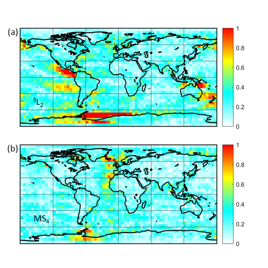
Figure 1 shows an example of the spatial structures of the semi-diurnal degree-3 tide 3L2 and the fourth-diurnal nonlinear tide MS4. Long time series are required to separate 3L2 from the larger degree-2 component L2. This effect is currently not included in almost any ocean tide model. MS4 was reduced from the distance measurements using a model, so the spectral amplitudes represent the error of the ocean tide model used.
Reference
- Koch, I., Duwe, M., Flury, J. (2024): Residual and unmodeled ocean tide signal from 20+ years of GRACE and GRACE-FO global gravity field models. Journal of Geophysical Research: Solid Earth, 129, e2024JB029345. doi.org/10.1029/2024JB029345

