GFZ's Satellite Laser Ranging (SLR) Station in Potsdam has been operating continuously as part of the global International Laser Ranging Service (ILRS) network since January 2003, i.e. already for 20 years. The SLR method was introduced in 1964 and is still one of the most accurate space geodetic techniques, whereby the measurement accuracy has been continuously improved.
Text: Prof. Dr. Frank Flechtner, GFZ

Sven Bauer, ehemals GFZ
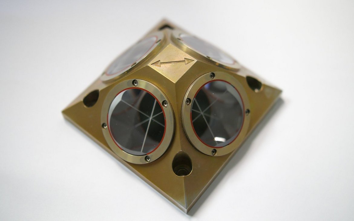
The principle of satellite laser ranging is relatively simple: a telescope is used to transmit short laser pulses in the direction of a laser retroreflector (LRR) on board of a satellite, such as GRACE or GRACE-FO. A small part of the signal is reflected by the LRR and captured again by the telescope. The two-way flight time (Earth-satellite-Earth) is calculated from the reception and transmitting time of the pulses at the station. With the speed of light and some corrections, e.g. for the path that the signal travels within the Earth's atmosphere, the exact distance between the satellite and the station at the time of the measurement can be derived. Special mirrors are used to maximise the reflection of the signal over the partly long distances (up to 25,000 km). The LRRs always reflect the light in the direction from which it came. This principle is also used in so-called "cat's eyes" to improve the safety of cyclists in road traffic. Satellites with laser reflectors on board are observed by SLR stations on all continents (with the exception of Antarctica) under the coordination of the ILRS. The accuracy of the SLR method is essentially determined by the technical parameters of the ground station and the quality of the mirrors on the satellite. The Potsdam laser station can measure the distance to satellites in orbits of 400 to 25,000 km above the Earth with an accuracy of around 1 cm and a precision of less than 1 cm.
SLR's main scientific contributions
Since 2003 the GFZ operates a qualified Analysis Centre (AC) within the ILRS and participates in all activities and pilot projects of the ILRS Analysis Working Group. The GFZ also routinely analyses SLR data from the LAGEOS-1 and -2 satellites for the generation of official daily and weekly products containing station coordinates and velocities as well as Earth orientation parameters (e.g. polar motion and duration of day) which contribute to the combined ILRS products. The daily combination is mainly used to predict Earth orientation parameters for the International Earth Rotation and Reference Systems Service (IERS). From time to time, multi-year SLR time series are reprocessed on request of the IERS for the development of new international coordinate systems, the "International Terrestrial Reference Frames" (ITRFs).
In addition, the GFZ uses the SLR observations to derive time-variable coordinates of the physically defined geocentre (Earth's centre of mass) relative to the geometrically defined origin of the ITRF as well as other static and time-variable long-wave coefficients of the Earth's gravitational fieldThe Earth's gravitational field is made up of the Earth's gravitational pull and the latitude-dependent centrifugal acceleration caused by the Earth's rotation. The matter in and on the Earth is not evenly distributed. Water, loose sediments (such as.... Furthermore, the SLR observations to GRACE or GRACE-FO are used to calibrate the corresponding satellite orbits independently of GPS.
Features of the Potsdam SLR station
The Potsdam SLR station is highly automated. Both transmit and reception telescopes and the complete electronics for distance measurement are computer-controlled. The highly centralised operating software was developed by the GFZ spin-off DiGOS GmbH Potsdam under Linux, which means that only one person is required for operation. Despite the small diameter of the receiving telescope of only 0.4 m compared to up to 1 m and more with other systems, the SLR system Potsdam shows a good signal yield at night and also during the day. The ILRS criterion for high-performance stations of 3500 observed passages per year have been consistently achieved and exceeded in recent years. Furthermore, the system has a good short and long-term stability of just a few millimetres. Since September 2011, a solid-state laser with a repetition rate of 2 kHz (previously 10 Hz) and shorter pulses (10 ps compared to 50 ps) has been in use, which has significantly increased the number of individual measurements per satellite passage. Such measurements are used, among other things, to determine the spin frequency and orientation of rapidly rotating spherical satellites such as Lares, Blits or Ajisai. In September 2017, the laser power was also increased from 0.8 to 1.4 W as part of a hardware upgrade. In May 2017, several space debris objects were also observed in bistatic experiments together with the SLR station in Graz (Austria). The Graz station sent laser pulses to the space debris objects for distance measurements, which were received by Graz itself and also at the Potsdam laser station. This means that distance measurements can be recorded by several stations simultaneously, although only one station transmitted laser pulses to the space debris objects. Such measurements allow the precise determination of the orbit of space debris within a very short time, whereby the additional observations from other stations improve the accuracy even further. The need to obtain accurate orbit predictions in the shortest possible time can become relevant, for example, in the event of imminent collisions of space debris with active satellites and the resulting necessary evasive manoeuvres.
The GFZ is currently working on further modernising the station and preparing it for the future.
Further Information
- Homepage International Laser Ranging Service
- More Information: Laser Ranging Station Potsdam
- Interview with Sven Bauer, head of the GFZ satellite ranging station
