The GFZ operates a satellite receiving station in Ny-Ålesund, Spitsbergen, to receive data from research satellites in polar orbits. It acts as the primary receiving station for the GRACE-FO satellites and is therefore required for the continuous, reliable reception of all GRACE-FO data.
Text: Prof. Dr. Frank Flechtner, GFZ
Many scientific satellites fly in low and polar orbits with short orbital periods of only around 95 minutes. These low orbits are favourable for many types of measurements, as the satellites are relatively close to the environment to be observed, i.e. the Earth's surface or the low atmosphere. The polar orbits enable observations to be made over all regions of the Earth, including the polar regions. It therefore makes sense to set up receiving stations for satellites near the poles.
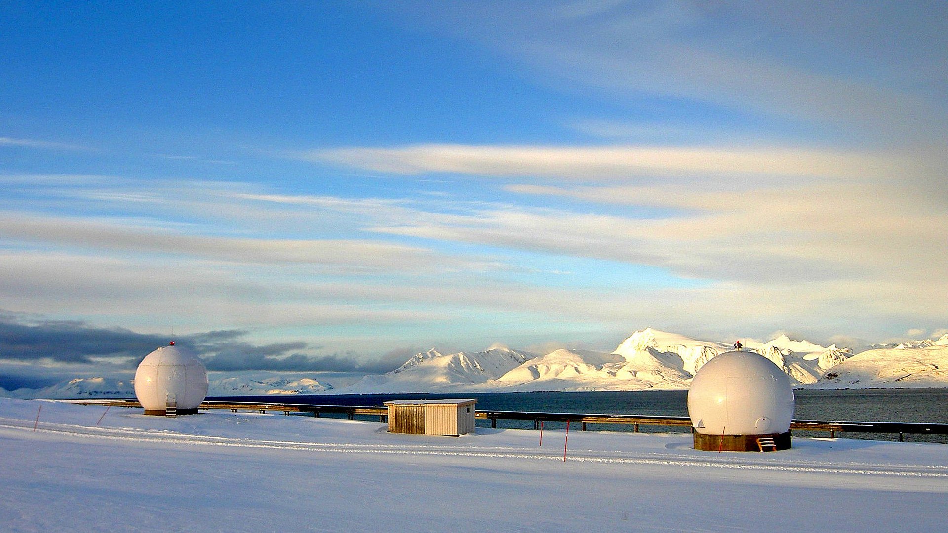
The satellite receiving station in Ny-Ålesund (NYA) on Spitsbergen (78° 55' North, 11° 56' East) is located about one kilometre outside the town, between the runway of the local airfield and the Kongsfjord. Ny-Ålesund is the northernmost place that can be reached by regular transport (aeroplane and ship), with a distance of only approx. 1200 km to the North Pole. Between 30 and 180 residents, made up of permanently stationed personnel and visiting scientists, is supplied by the Norwegian Kings Bay Company, which also operates the infrastructure of the town, i.e. the harbour, the road network and the energy supply.
Currently, the NYA station's most important task is to receive data from the two GRACE Follow-On satellites, which have been in orbit since 2018. The GFZ is responsible for the continuous and complete reception of the satellite data. The station is also firmly planned as the primary receiving station for the follow-up mission, which is to continue the GRACE and GRACE-FO time series from 2028.
The operating costs of the NYA station are comparatively low, which is due in particular to the largely automated, unmanned operation. This enables the GFZ to support other satellite missions that do not have the resources for expensive contacts with other ground stations. Examples of this are the Flying Laptop satellite (built at the University of Stuttgart), which has been in operation since 2017, and the TUBIN satellite (built at the Technical University of Berlin), which has been in operation since 2022.

Bild: Carsten Falck, GFZ
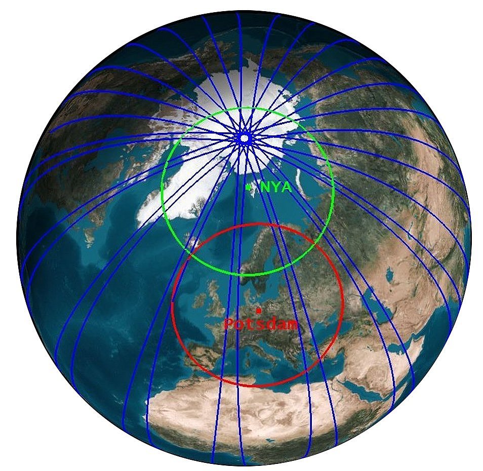
Satellites must be within the visibility range of ground stations in order to be able to regularly transmit their data to Earth. The diagram below shows the visibility range of Potsdam (red circle) and that of the Ny-Ålesund station (green circle). The ground tracks of the orbits of both GRACE-FO satellites over 24 hours (blue lines) cross the visibility range of the Potsdam site only about 4 times a day due to the Earth's rotation. The age of the data received by the GRACE-FO satellites in Potsdam (and other locations in these geographical latitudes) can therefore not be less than about 6 hours on average. In contrast, the Ny-Ålesund station, due to its location at a much higher latitude, can establish an average of more than 15 contacts with each of the satellites in the same period (24 hours), regardless of the Earth's rotation, resulting in a maximum data age of ca. 1.5 hours.
What are the specific benefits of the Ny-Ålesund receiving station?
Regular, timely data reception at the NYA station is an important prerequisite for many time-critical applications. One example is satellite-based GNSS (Global Navigation Satellite System) atmospheric sounding, an innovative method for determining temperature and water vapour profiles, which helps to improve weather forecasts, among other things. The measurements are carried out on satellites with special GNSS receivers, such as those installed on GRACE and GRACE-FO. The products delivered to the weather centres must not be older than three hours - this is achieved in particular through the timely satellite reception in Ny-Ålesund.
Another example is the operational provision of precise orbit predictions for the ILRS (International Laser Ranging Service) based on GNSS data recorded on the satellites. This enables the laser stations distributed around the world (e.g. the SLR station in Potsdam) to align their laser instruments more precisely with the satellites. This enables high coverage of the satellite orbits with precise laser measurements.
In addition to the scientific benefits, frequent and regular contacts with the satellites also enables quasi-continuous monitoring of the satellites and their instruments. This allows technical problems to be recognised at an early stage and critical situations to be prevented. This can help to reduce downtimes and support a long lifetime of the monitored satellites.
Further Information
- More information about the satellite receiving station on the GFZ webpage
- History of the satellite receiving station (PDF)
